We had major earthquakes off the coast of Baja California this morning- and already the USGS is creatively editing the information.
Dutchsinse posted this video around 4:30am CST this morning- outlining the 6.4 and 6.1 magnitude earthquakes off the coast of California, and two earthquakes in Nevada and Utah 3.5 and 3.2 mag that immediately followed. Dutch outlines the earthquakes in a brief report below:
BUT..... by the time I got my lazy ass out of bed at 6:30am EST the USGS had already been doing some creative editing. The 6.1 magnitude earthquake has completely disappeared from their charts along with the 3.5 and 3.2 in Nevada and Utah. As a matter of fact if you click on the links that Dutch provided here: http://www.youtube.com/watch?v=nkGhkIMiZHc You'll see that the USGS has oh so creatively combined the two earthquakes into one. Interesting.
byAnthony Gucciardi December 3rd, 2012 | Updated 12/03/2012 at 5:11 am
Have you heard of the massive sinkholes popping up around the nation? Flammable craters spanning acres wide and leaking radiation, monster sinkholes described as ‘apocalyptic’ have forced residents out of homes, expelled radiation into the environment, and are now ushering in concerns about serious Earth changes in the near future. If you’ve heard of these sinkholes, chances are it has been from the alternative media.
It’s a hot issue on forums, some social networking sectors, and certain alternative talk radio programs. Sure, it has come up in some mainstream reports here and there, but there are virtually no in-depth pieces tying everything together. And they often fail to mention the scale of these sinkholes, behemoth anomalies that can swallow up 100 foot trees, houses, with the latest Ohio sinkhole devouring 4 football fields of land. Events that are sending residents scrambling.
You can see a video of the Ohio sinkhole below:
Fracking, Drilling, Mining Responsible for Sinkhole Changing Earth Events?
A more serious issue, even beyond the dangers posed by these radiation-leaking sinkholes, is how man-made processes like fracking and excessive drilling are changing the planet on a larger scale. Bloomberg reports that fracking is a likely cause for a dramatic rise (sixfold) in earthquake activity from 2000 to 2011. Not to mention contamination of the water and food supply.
Extreme mining practices by Texas Brine and others are also responsible for triggering the sinkholes.
So are these actions ‘waking up’ the New Madrid fault line? In case you’re not familiar, the New Madrid fault line was responsible for the legendary 1811-1812 earthquakes dubbed the ‘New Madrid’ earthquakes. Extremely powerful and devastating earthquakes that are the most significant earthquakes to hit the United States in all of recorded history. As Investment Watch explains, the research indicating fracking and excessive mining in the expansion of earthquakes along the Madrid line reveals a concerning and plausible reality.
It is important to note that the New Madrid fault line includes areas within Illinois, Indiana, Missouri, Arkansas, Kentucky, Tennessee and Mississippi. In the event of a large (8.0 or higher) earthquake along the fault line, however, a much greater area would likely be affected.
Outside of the repercussions of the sinkholes, such as the radiation issue and major possibility of implosion or massive disruption in the area, what are the larger consequences of invasive fracking? Could a massive disaster be the result of greedy corporations endangering the entire nation? Furthermore, why is the mainstream media shying away from the issue completely?
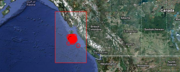
Canada’s Queen Charlotte Islands region struck strong aftershock at 18:54 UTC on October 28, 2012according to USGS. This is still preliminary magnitude but the event was reviewed by seismologist. Epicenter was located 159 km (98 miles) SSW of Masset, Canada at coordinates 52.633°N, 132.701°W. Recorded depth was 8.2 km (5.1 miles).
EMSC reported this earthquake as magnitude 5.8 with depth of 5 km.
Magnitude
6.3
Date-Time
Sunday, October 28, 2012 at 18:54:21 UTC
Sunday, October 28, 2012 at 11:54:21 AM at epicenter
Location
52.633°N, 132.701°W
Depth
8.2 km (5.1 miles)
Region
QUEEN CHARLOTTE ISLANDS REGION
Distances
159 km (98 miles) SSW of Masset, Canada 245 km (152 miles) SW of Prince Rupert, Canada 343 km (213 miles) SW of Terrace, Canada 595 km (369 miles) WNW of Campbell River, Canada
Location Uncertainty
horizontal +/- 18.5 km (11.5 miles); depth +/- 6.5 km (4.0 miles)
Parameters
NST=281, Nph=281, Dmin=317.3 km, Rmss=1.32 sec, Gp= 83°, M-type=regional moment magnitude (Mw), Version=8
Saturday, October 27, 2012 at 08:04:10 PM at epicenter
Location
52.769°N, 131.927°W
Depth
17.5 km (10.9 miles)
Region
QUEEN CHARLOTTE ISLANDS REGION
Distances
139 km (86 miles) S of Masset, Canada 202 km (125 miles) SSW of Prince Rupert, Canada 293 km (182 miles) SW of Terrace, Canada 556 km (345 miles) NW of Campbell River, Canada
Location Uncertainty
horizontal +/- 14 km (8.7 miles); depth +/- 4 km (2.5 miles)
Parameters
NST=716, Nph=716, Dmin=267.2 km, Rmss=0.95 sec, Gp= 58°, M-type=regional moment magnitude (Mw), Version=A
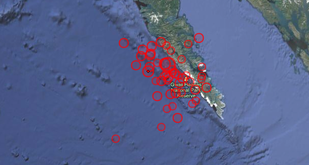
The October 28th, 2012 (October 27 at the location of the epicenter) M 7.7 earthquake south of Masset, Canada, occurred as a result of oblique-thrust faulting near the plate boundary between the Pacific and North America plates. At the location of this event, the Pacific plate moves approximately north-northwest with respect to the North America plate at a rate of approximately 50 mm/yr.This earthquake is likely associated with relative motion across the Queen Charlotte fault system offshore of British Columbia, Canada. Studies of tectonics in this region suggest plate motions are taken up by strike slip faulting parallel to the plate boundary, accompanied by lesser amounts of thrust motion to accommodate the oblique nature of the plate motion vector between the two plates with respect to the orientation of the main plate boundary fault structure. This oblique component of plate motion may involve either underthrusting of the western edge of the Pacific Plate beneath North America, or be taken up on crustal faults within the North America plate. The October 28th earthquake is consistent with either scenario. Its rupture extended approximately 100-150 km along strike, along the shallow extent of the source fault. Slip amounts reached approximately 5m, in a patch to the south of the epicenter. Aftershocks delineate the rupture well, as shown here.
This region of the Pacific:North America plate boundary has hosted 7 earthquakes of magnitude 6 or greater over the past 40 years – the largest of which was a M 6.6 earthquake in 2009, 80 km to the south east of the 2012 earthquake. In 1949, a M 8.1 earthquake occurred closer to the Pacific:North America plate boundary, likely as a result of strike-slip faulting, approximately 100 km northwest of the October 28th earthquake, near the northern extent of Haida Gwaii region (formerly Queen Charlotte Islands). Summary report.
edited 10:28 4:14pm est more earthquakes including a 6.3M just over an hour ago- bringing the total to 51 edited 10/28 1:56pm est Since the first 7.7 M earthquake last night, there has been a constant earthquake swarm- 33 quakes between 4.0 -5.1 Magnitude quakes. Late last night a 7.7 magnitude earth quake hit the Queen Charlotte Islands off the west coast of Canada- this was followed by several more earthquakes in the 4-5 magnitude range. A Tsunami alert was issued, and has just been cancelled 45 minutes ago: http://www.google.org/publicalerts/alert?aid=e03a6e895721fff1&hl=en&gl=US&source=maps Here is Dutchsinse's report on the event- please note the amount of earthquakes, of magnitude 4.0 or greater, that have hit the west coast of North America in the past 7 days.
SuspiciousObservers report for today:
My friends, it's not "Fear Porn", it's a reality wake up call. Our planet is shifting (in more ways than one), and we need to Be Prepared!
I've been keeping my eye on sunspot 1598 since it appeared revolving into earthview, and I had a niggling feeling that this bad boy wasn't going to go out quietly. Guess I was right. Two days ago 1598 popped off two M class solar flares, both with CMEs which should impact earth with just a glancing blow today/tomorrow, and a hand full of C's. Then last night 1598 gave us an M5 followed by an Xclass X1.8 Flare. The good news is that neither produced a CME, the bad news is that 1598 is just rotating into earth view and is all geared up to party some more. The flares did cause radio black outs, but only for an hour or so on the sunlit side of earth. Current Solar Forcast as spot 1598 rotates into direct earth view is 80% chance of M class, and 20% chance of X Class flares.
SuspiciousObservers video update for today has a lot of important information.
Some important info in todays SuspisciousObservers update. Besides the tectonic shifts in the sea floor in different areas, the earthquakes and rumbling volcanoes, we are currently in a solar high alert zone. Yesterday an M9 class solar flare popped off just as sunspot 1598 started turning into earth view. Right now the Earths magnetic field is far from perfect, and while the chance of an Xclass flare is only around 10% that doesn't mean we couldn't get slammed with one anyway.
Here is Dutchsinse's run down of the 5.3M of the earthquake in California this morning. Click HERE for Dutch's impressive list of links for every bit of info you could ever ask for on the topics of earth sciences.
There is a lot of things happening right now- not only on our physical planet and our corner of space, but politically and economically. Major changes are afoot. Are you prepared? Anyone who follows my ramblings should know that I'm not into fear porn, nor am I one to promote doom and gloom- quite the opposite. BUT.... it isn't fear porn and scare tactics to point out that being prepared is vital right now. Yes, we need to focus on the positive, but to deny that our world is drastically changing is just stupid. Be positive, but also Be Prepared!!!!
Edited 10/17 1pm est: http://theunhivedmind.com/wordpress2/?p=8585 More and more questions coming up from the explosion(s) in Louisiana that I reported on yesterday. I will be following this story closely- along with several friends of mine. I will update here as more information becomes available. Below the video are the notes and links from the YouTube page and several of the links are ones that I posted yesterday.
Really sloppy cut & paste journalism? Or purposely misleading...things get weirder by the day in Louisiana...More information will be uploaded later from Nuked Radio episode that aired today.
Comment on Yahoo news: "I have a close friend that works for the Fire Dept. in that area. He told me the state police wont even let them near the site. Why wouldnt you want the fire department at the scene of a huge explosion? He also stated it seemed like they where trying to "buy time". All sounds very sketchy to me..."
BECAUSE ^^^ THEY ARE HIDING SOMETHING.
We also have this report of ash falling down after the explosion- as reported on main stream tv.
On top of this, yesterday there was a very rare earthquake in Maine - USGS calling it a 4.0, yet was originally reported as a 4.8- http://earthquake.usgs.gov/earthquakes/recenteqsww/Quakes/usb000d75b.php Dutchsinse gives an update on the Louisiana sink hole issue HERE and gives information about plumes from the Pinacate volcano just south of Arizona HERE - both articles have multiple links to further information.
And a swarm of earthquakes in Yellowstone - that the USGS is editing, actually deleting some of the recorded information:
The USGS has been deleting and altering earthquake and volcanic activity records, sometimes altering the magnitude of the earthquake, sometimes deleting it all together. Not good folks. Not good at all. As for the Louisiana explosions..... they are a cover up.
We are currently in a geomagnetic storm, and a strong one at that. Besides effecting various electronics, GPS, Cellphone signals etc... these storms also effect humans as well. Be extra careful while driving and beware the road rage monster.
I'm watching the area of the Med very closely right now. As I've said in previous articles, the area around Greece, Italy and Turkey has been shaking a LOT recently. As SuspiciousObservers points out, one of the earthquakes that hit early this morning registered over 6 by one centre. I'm going to call some friends over there this morning to see how they are faring.
....once I have more coffee in my system.
SuspiciousObservers outlines some of the physical events on our planet yesterday. We awaiting the impact of an earthbound CME tomorrow, and because we are still currently experiencing the tail end of a geomagnetic storm, let's cross our fingers that it doesn't get too crazy.
I will tell you that the freak storm in Malta was unbelievable- THIS is NOT normal for Malta
As I discussed last month, there have been swarms of shallow low grade earthquakes in the area of the Greek Island- literally hundreds. In the past month there have been 652 earthquakes of 2.5 magnitude or greater and 487 of them were 10km deep OR LESS.
EMSC today- one month, 2.5 mag or greater
Even more worrying is the continuous stream of earthquakes happening around the Virgin Island in the Caribbean. 371 earthquakes in the past 7 DAYS of 2.5 or greater.
Dutchsinse put out two updates this weekend that were very important. The First one is about the Cyber Summit Videomakers Conference where Dutch did presentations on weather modification, earthquakes and volcanoes, fracking and HAARP. Dutch posts an amazing assortment of videos in this article- literally hours and hours worth of excellent education on all these topics. To read his original article and watch the embedded videos click HERE
The second update is about a HAARP ring that appeared over Dover Delaware on Sept 1st, and yesterday the National Weather Service issued a tornado warning for..... you guessed it: Dover Delaware!! Click HERE to go to Dutch's original article to watch the video.
On September 1, 2012 — a high frequency flash ‘HAARP ring’ appeared out of Dover Delaware — several HAARP ring researchers saw it occur, and watched for severe weather to develop within approx 48 hours.
————–
CONFIRMATION:
Today , September 3, 2012 — within the 48 hour time period — the National Weather Service issued a tornado WARNING for Dover Delaware. No other adjacent areas.. just Dover.
I'm going to start posting the video daily updates from Suspicious0bservers - They post a short 2-3 minute video everyday that outlines the physical realm of our planet and solar system, giving the watcher accurate updates as to what is going on around us and what we need to be aware of.
Always Check the Foreign News Sources as well!!! Iran: Mehr News, TehranTimes China: Xinhua, China.org, Chinadaily Asia Times dot Com Russia: Ria Novosti Israel: Jerusalem Post, Israel National News, Haaretz M/E: ArabNews, AlJazeera


 Have you heard of the massive sinkholes popping up around the nation? Flammable craters spanning acres wide and